Indian River artesian wells, 1892 to 1913
The Indian River artesian wells north of Fort Pierce came early and did not go deep. At Narrows, Orchid, Roseland and Sebastian, flowing wells were drilled in the 1890s, a decade before the Fort Pierce ice plant bored its well in 1905, and most of them struck water at 350 to 500 feet, where Fort Pierce had to go down 812. In 1910 and 1911 a new farm company at Fellsmere put down wells of its own. The state survey of 1913 gathered what was known about all of them, and this page goes through it, town by town.
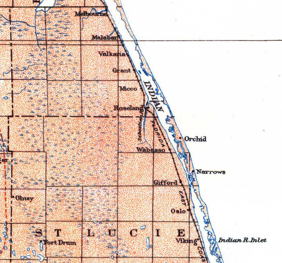
Which county the up-river wells were in
St. Lucie County was only eight years old in 1913, and the two government surveys published that year did not file these wells the same way. The state survey, by E. H. Sellards and Herman Gunter, put Narrows, Orchid, Roseland, Sebastian and Fellsmere under St. Lucie County. The federal survey listed the wells near Orchid and Roseland in its table for Brevard County, even though its own map, above, draws the county line by Roseland with Orchid well to the south of it. This page follows the state survey, which has the fuller account of each well.
Indian River artesian wells, town by town
The state survey’s notes on each place are short, and some of them say plainly that the details had been lost. At Roseland the wells had been drilled for a number of years, and for that reason, the survey wrote, no very definite information could be obtained.
- Narrows: two wells, owned by F. Foster and E. L. Gray, drilled by W. J. Nesbitt about 1892. Both three inches across and 420 feet deep, with a head of several feet and a strong flow.
- Orchid: S. K. Michael’s well, sunk by Capt. Alexander Near in 1896. 480 feet deep, four inches, cased 85 feet, with a head reported at 40 feet above sea and an abundant supply of hard sulphur water.
- Roseland: three wells owned by L. C. Moore, about a mile and a half north of Roseland on the point between the Sebastian and Indian rivers, 350 to 453 feet deep, used for irrigation and general purposes.
- Sebastian: several flowing wells in and near the town, 365 to 500 feet deep, the water rising 16 to 25 feet or more above the ground. J. A. Groves’s well, finished in 1896, went to 460 feet.
- Fellsmere: the Fellsmere Farms Company’s well, about ten miles west of Sebastian, 370 feet deep and four inches across, tested in September 1910 at a head of 25 feet and a flow of 185 gallons a minute.
The same names turn up more than once. W. J. Nesbitt, who drilled the Narrows wells, also drilled a 350-foot well at Valkaria in Brevard County in 1892, and a firm called Fee & Nesbitt sank the deep well at Eden, south of Fort Pierce. Captain Near drilled at Orchid in 1896 and at Sebastian in 1901.
Why the wells were shallower up the river
Every deep well on this stretch of coast was after the same thing: the limestone the 1913 surveys called the Vicksburg, the principal water-bearing rock of eastern Florida. The state survey explained that these limestones dip as they run south, which is why they lie deeper in St. Lucie County than in the counties to the north.
The same pattern shows inside the county. The up-river wells found their flows at 350 to 500 feet; at Fort Pierce, farther south, the ice company’s wells went to 812 feet and the railway’s well of 1912 to 814. Our page on the Fort Pierce artesian wells follows the railway’s drill down through 647 feet of sand and clay before it reached the rock.
Hard water that smelled of sulphur
The state survey describes the up-river water the same way at almost every stop: hard, and carrying sulphur. At Orchid it was hard sulphur water; at Roseland it was hard and impregnated with hydrogen sulphide, the gas that smells of rotten eggs; at Sebastian it was hard sulphuretted water. People used it for irrigation, for general purposes and, at Sebastian, in the house.
One Sebastian well had a trade of its own. The Indian River Cooperage Company’s well, drilled by Captain Near in 1901, was 365 feet deep. When it was first sunk, four years before the Fort Pierce ice plant finished its 812-foot well, it was used for the manufacture of ice. By 1913 it was abandoned.
The water up the river was not free of salt, but the one analysis printed for it came out lower than Fort Pierce’s. The State Chemist found 257 parts per million of chlorine in the Fellsmere well; an analysis of one of the Fort Pierce ice company’s wells, printed earlier in the same county section of the report, found 447.
Fellsmere, 1910 and 1911
The newest wells on this stretch were the farm company’s. In September 1910 The St. Lucie County Tribune’s Sebastian news reported that the Sebastian and Fellsmere railroad was finished to the site of the future town, and that two men, one of them from Micco, had just completed three artesian wells at Fellsmere, with a combined depth of twelve hundred feet and a strong flow from all three. On September 23 the company’s manager tested a Fellsmere Farms well and sent the figures to the State Chemist, and those are the figures the 1913 survey printed.
By February 1911 the railroad had been extended northward and the Micco driller had moved out to the end of the extension to put down another well, leaving one inside the town limits to finish later. That would make five artesians in and around Fellsmere, the Tribune said. In April a long description of the Fellsmere tract in the Fort Pierce News, written as the land was coming onto the market, gave the company’s own figures: four four-inch wells so far, 370 to 430 feet deep, flowing from 185 to 275 gallons a minute.
Sources
The well records come from E. H. Sellards and Herman Gunter, “The artesian water supply of eastern and southern Florida,” Florida Geological Survey, Fifth Annual Report (1913), pages 245, 246 and 248 to 250 (Internet Archive). The map and the Brevard County table come from G. C. Matson and Samuel Sanford, Geology and Ground Waters of Florida, U.S. Geological Survey Water-Supply Paper 319 (1913), Plate I and the table of principal wells of Brevard County facing page 276 (USGS).
The Fellsmere news comes from The St. Lucie County Tribune of September 9, 1910, page 3 and February 3, 1911, page 6, and the Fort Pierce News of April 28, 1911, page 1, digitized by the Library of Congress in Chronicling America.
Frequently asked questions
How deep were the artesian wells along the Indian River?
North of Fort Pierce, from Narrows to Sebastian and out to Fellsmere, the wells the 1913 state survey recorded ran from 350 to 500 feet. At Fort Pierce the deep wells went to 812 and 814 feet.
Why were the wells deeper at Fort Pierce?
The 1913 state survey explained that the water-bearing limestone dips as it runs south. The depths it recorded along the river fit that: shallower wells to the north, and the deepest at Fort Pierce.
What was the artesian water like?
Hard, and smelling of sulphur, at Orchid, Roseland and Sebastian. The one analysis printed for the up-river wells, from Fellsmere, found less chlorine than an analysis of a Fort Pierce well in the same report.