Florida's geological timeline: 500 million years of change
Florida seems like one of the youngest landscapes in North America: low, flat, and composed of geologically recent sediments. In one sense, this is true: the land surface we walk on today is mostly Pleistocene and Holocene in age, formed within the last two million years. Yet beneath this young veneer lies an ancient geological history that connects Florida to the African continent, to vanished oceans, and to some of the most dramatic events in Earth's geological past.
Tracing Florida's geological timeline requires drilling deep, both literally and figuratively. The rocks exposed at the surface tell only the most recent chapter. The full story is known from deep well cores, seismic surveys, and careful geological mapping that have revealed a sequence of events spanning half a billion years.
Precambrian and early Paleozoic: African origins (>500 million years ago)
Florida's geological timeline begins not in North America but in Africa. The deepest basement rocks beneath the Florida Platform, encountered only in deep well cores at depths of several thousand feet, are igneous and metamorphic rocks dating to the Precambrian and early Paleozoic eras. These ancient rocks, including granites, gneisses, and volcanic rocks, match the geology of West Africa rather than the Appalachian basement of the southeastern United States.
The African origin is well established: radiometric dating, mineral composition analysis, and paleomagnetic studies all show that Florida's basement rocks were part of the Gondwana supercontinent, the southern landmass that included Africa, South America, India, Antarctica, and Australia. During the early Paleozoic, what would become Florida was attached to the northwestern margin of Africa.
Late Paleozoic: Pangaea assembly (~350–250 million years ago)
During the late Paleozoic, the collision of Gondwana (including the Florida fragment) with Laurentia (ancestral North America) formed the supercontinent Pangaea. This collision also built the Appalachian Mountains, ironically the same mountains whose erosion would eventually supply the quartz sand that makes up Florida's beaches today.
During the Pangaea period, the Florida fragment was sandwiched between Africa and North America, far from any ocean. There are no sedimentary deposits from this era in the Florida geological timeline: it was a period of erosion and tectonic compression rather than deposition.
Mesozoic: rifting and the birth of the Florida Platform (~250–66 million years ago)
Triassic–Jurassic: the Atlantic opens
Beginning roughly 200 million years ago, Pangaea began to rift apart. As Africa separated from North America, the Atlantic Ocean opened between them. The Florida fragment stayed with the North American plate rather than returning to Africa. This rifting created the fundamental geological architecture of the Florida Platform: a broad, shallow shelf on the trailing edge of a separating continent.
As the rift valley subsided and was flooded by marine waters, the first carbonate sediments began accumulating on the Florida Platform. This was the beginning of the limestone deposition that would continue, with interruptions, for the next 200 million years.
Cretaceous: thick carbonate deposition (~145–66 million years ago)
During the Cretaceous period, the Florida Platform was completely submerged beneath warm, shallow tropical seas. Conditions were ideal for carbonate production: warm water, abundant marine life, and a stable, slowly subsiding platform. Thousands of feet of limestone and dolostone accumulated during this period, forming the deep foundation of the Florida geological timeline.
The Cretaceous carbonates of the Florida Platform include thick reef complexes, shallow-water limestones, and deeper-water chalk deposits. These rocks are the ultimate foundation of Florida's modern rock formations: every younger formation sits atop this Cretaceous carbonate base.
Paleogene: warm seas and the Ocala Limestone (~66–23 million years ago)
Eocene (~56–34 million years ago)
The Eocene epoch was a warm period in Earth's history, and Florida remained entirely submerged. The most significant geological product of this era in Florida's geological timeline is the Ocala Limestone, a thick, pure limestone unit deposited in clear, warm marine waters during the late Eocene (approximately 40–34 million years ago).
The Ocala Limestone is critically important to modern Florida because it forms the primary component of the upper Floridan Aquifer, one of the most productive groundwater systems in the world. The porosity and permeability of this Eocene limestone, a direct result of its depositional environment and subsequent dissolution by groundwater, make it capable of yielding enormous volumes of water. Florida's famous springs, including Silver Springs, Rainbow Springs, and Wakulla Springs, discharge directly from the Ocala Limestone.
Oligocene (~34–23 million years ago)
During the Oligocene, parts of northern Florida may have briefly emerged above sea level for the first time, the earliest appearance of "land" in the Florida geological timeline. The Suwannee Limestone, deposited during this period, represents continued shallow marine conditions across much of the platform.
Neogene: phosphate, fossils, and fluctuation (~23–2.6 million years ago)
Miocene (~23–5.3 million years ago)
The Miocene epoch brought dramatic changes to Florida's geological timeline. The Hawthorne Group, a complex assemblage of phosphatic clays, sands, and limestones, was deposited across much of the state during this period. The Hawthorne Group is geologically significant for several reasons:
- It contains Florida's enormous phosphate deposits, which make the state one of the world's largest phosphate producers.
- It acts as a confining layer over the Floridan Aquifer; where the Hawthorne has eroded away, the aquifer is unconfined and vulnerable to sinkhole formation.
- It preserves an extraordinary fossil record of Miocene marine and terrestrial life, including the ancestors of many species whose teeth and bones are found on Treasure Coast beaches today.
Pliocene (~5.3–2.6 million years ago)
During the Pliocene, sea levels fluctuated and Florida alternated between marine and terrestrial conditions. The Tamiami Formation and equivalent units were deposited during marine high stands. The fossil record from this period includes both marine organisms and terrestrial animals, reflecting the transitional nature of the environment. By the late Pliocene, climate was cooling toward the ice ages that would define the next chapter in Florida's geological timeline.
Pleistocene: ice ages and the emergence of modern Florida (~2.6 million–11,700 years ago)
The Pleistocene epoch, the "Ice Age," was the most transformative period in Florida's recent geological timeline. Repeated glacial-interglacial cycles caused sea levels to swing by 300 to 400 feet, alternately flooding and exposing the Florida Platform.
During glacial maximums, enormous ice sheets covered much of northern North America, locking up so much ocean water that sea levels plummeted. Florida expanded to roughly twice its current area, and the exposed continental shelf became dry land: vast grasslands and savannas populated by mammoths, mastodons, giant ground sloths, saber-toothed cats, horses, and camels.
During interglacial periods, the ice melted, sea levels rose, and much of Florida was re-submerged. It was during the Sangamonian interglacial (~126,000–110,000 years ago) that the Anastasia Formation, the coquina limestone underlying the modern Atlantic coast, was deposited.
The Pleistocene fossil record of Florida is one of the richest in North America. The state's rivers, sinkholes, and coastal deposits have yielded remains of more than 100 species of vertebrates from this period, which is what draws fossil hunters to the state.
Holocene: the modern landscape (~11,700 years ago to present)
The Holocene epoch, our current geological period, began with the end of the last ice age. As global temperatures rose and ice sheets melted, sea levels climbed from their glacial-maximum low to approximately their present position by about 6,000 years ago.
This post-glacial sea level rise reshaped Florida's geological timeline into its modern form:
- Barrier islands formed along the Atlantic coast as rising seas reworked coastal sediments.
- The Indian River Lagoon was created as the low-lying area behind the barrier islands flooded.
- Mangrove forests colonized the Gulf coast, trapping sediment and building new land.
- The Everglades formed as rising water tables created the freshwater wetlands of South Florida.
- Modern beach and dune systems developed along both coasts.
Today, Florida's geological timeline continues to unfold. Sea levels are rising, coastlines are shifting, sinkholes are forming, and sediment is being deposited. The same geological processes that have shaped Florida for hundreds of millions of years remain active, connecting the deep past to the present in ways that affect every Floridian.
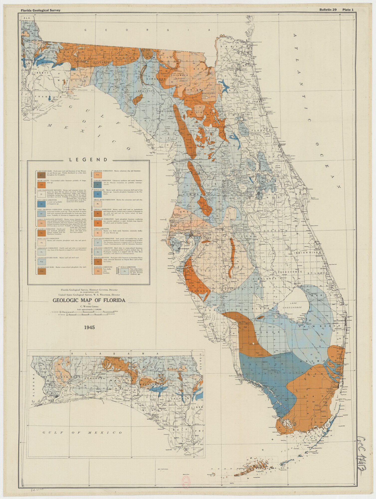
What the 1945 legend says
The legend printed on the plate above is too small to read at the size the map appears here. This is what it says, transcribed from the plate itself. Each unit is keyed to the map by the symbol in brackets, so you can open the image at full size and match a color to its formation. The plate spells the Hawthorn Formation two ways, "Hawthorn" in one entry and "Hawthorne" in another, and both are left here as they appear on it.
Pleistocene series
- Lake Flirt Marl (Qlf). Fresh-water marl and limestone of late Wisconsin and Recent ages. Widely distributed as a thin sheet throughout the Everglades.
- Miami Oolite (Qm). Cross-bedded oolitic limestone probably of Sangamon age.
- Late Pleistocene deposits (Ql). Marine and estuarine terrace deposits less than 100 feet above sea level, including the Anastasia, Wicomico, Penholoway, Talbot, and Pamlico formations, having shore lines about 100, 70, 42, and 25 feet above sea level. Probably of Sangamon and middle Wisconsin ages. Vast areas in the western part of the Peninsula have been omitted.
- Key Largo Limestone (Qk). A coral reef probably of Sangamon age.
- Fort Thompson Formation (Qf). Including the Coffee Mill Hammock marl member at the top. Three thin beds of marine shell marl separated disconformably by fresh-water limestone. Probably of Aftonian to Sangamon ages, inclusive.
- Early Pleistocene deposits (Qe). Marine terrace deposits, chiefly sand, probably including remnants of the Brandywine and Coharie formations and more extensive areas of the Sunderland formation, having shore lines about 270, 215, and 170 feet above sea level. Probably of Aftonian and Yarmouth ages. The boundary is very much generalized, and large areas have been omitted.
Pliocene series
- Alachua Formation (Pa). Chiefly sand and hardrock phosphate deposit residual from the Hawthorn formation.
- Bone Valley Formation (Pb). Marine and estuarine phosphatic sand, clay and gravel.
- Citronelle Formation (Pc). Chiefly sand and white or iron-stained clay. Some of the deposits so mapped are early Pleistocene.
- Caloosahatchee Marl (Pca). Marine sand and shell marl.
- Buckingham Marl (Pbm). Marine cream-colored phosphatic clay marl.
- Charlton Formation (Pch). Marine calcareous clay and limestone.
- Tamiami Formation (Pt). Calcareous sandstone and sandy limestone. All the Pliocene formations are probably contemporaneous.
Miocene series
- Duplin Marl (Md). Marine sandy and clayey micaceous shell marl of late Miocene age. Coarsely phosphatic limestone in the Peninsula.
- Shoal River Formation (Ms). Marine fine micaceous sand and clay.
- Chipola Formation (Mc). Marine sandy shell marl on Apalachicola and Chipola Rivers; farther west it consists of limestone in the south and sand and clay farther inland. Of basal Hawthorne age.
- Hawthorn Formation (Mh). Sandy phosphatic limestone weathering into vesicular sandstone or sand. Includes large deposits of fuller's earth in Gadsden County.
- Tampa Limestone (Mt). Marine very finely sandy limestone, commonly chalky. Of early Miocene age.
Oligocene series
- Flint River Formation (Of). Sand, gravel, and mottled clay, in part residual from limestone, locally containing masses of chert. The Suwannee limestone is mapped with it in Washington County. Contemporaneous with the Suwannee limestone.
- Suwannee Limestone (Os). Hard white to cream-colored limestone, commonly containing pockets of green residual clay. In Washington County it is mapped with the Flint River formation, with which it is contemporaneous.
- Byram Limestone (Ob). Hard pure white limestone on Suwannee River; sandy yellowish limestone on Chipola River and in Walton County.
- Marianna Limestone (Om). Pure chalky white limestone.
Eocene series
- Ocala Limestone (Eo). Pure white homogeneous limestone of late Eocene (Jackson) age.
The plate carries its own title block below the legend: Florida Geological Survey, Herman Gunter, Director, in cooperation with United States Geological Survey, W. E. Wrather, Director. Geologic Map of Florida by C. Wythe Cooke, scale approximately 1/1,000,000, 1945.
Frequently asked questions about Florida's geological timeline
What is the oldest rock in Florida?
The oldest rocks known from Florida are Precambrian to early Paleozoic igneous and metamorphic basement rocks encountered in deep well cores. These rocks, granites, rhyolites, and gneisses, are estimated to be 500 million to over 1 billion years old. They originated as part of the African continent and were left behind when Pangaea rifted apart.
When did the Floridan Aquifer form?
The Floridan Aquifer formed within the carbonate rocks deposited during the Paleogene period, primarily in the Eocene-age Ocala Limestone and associated formations. The aquifer developed as groundwater dissolved pathways through the porous limestone over millions of years. The Floridan Aquifer is one of the most productive aquifer systems in the world, supplying water to millions of Floridians.
How do geologists know Florida was part of Africa?
Multiple lines of evidence connect Florida's basement to Africa: radiometric dating of basement rocks yields ages matching West African geology; mineral and rock composition analysis shows African-type igneous and metamorphic suites; paleomagnetic data places these rocks at latitudes consistent with West Africa during the Paleozoic; and seismic surveys reveal a structural boundary (the Suwannee Suture) separating Florida's African-origin basement from the Appalachian-origin basement of Georgia.
Why is Florida so flat if it has such old rocks underneath?
Florida's flat terrain reflects its geological origin as a marine carbonate platform. Unlike the Appalachian states, which were shaped by mountain-building tectonic forces, Florida accumulated its geological layers horizontally on a shallow sea floor. The deep basement rocks, no matter how old, are buried under thousands of feet of flat-lying sedimentary deposits. The surface we walk on is young, flat marine and coastal sediment deposited on this ancient but level foundation.