Understanding Florida Sinkholes: Causes, Science & Safety
Few geological phenomena capture public attention like a Florida sinkhole. When the ground suddenly opens and swallows a portion of a yard, road, or building, the event makes headlines across the country. But Florida sinkholes are not random acts of geological chaos — they are the predictable result of well-understood geological processes operating on the specific rock types that underlie the state. Understanding how and why Florida sinkholes form is essential for living safely in a landscape built on soluble limestone.
Why Florida Is Sinkhole Country
Florida sinkholes exist because the state sits on a foundation of carbonate rock — limestone and dolostone — that is susceptible to chemical dissolution by water. This foundation, known as the Florida Platform, is thousands of feet thick and was deposited over hundreds of millions of years beneath warm, shallow seas (see our geological timeline for the full story).
The key chemical process is straightforward: rainwater absorbs carbon dioxide from the atmosphere and soil, forming a weak carbonic acid. This slightly acidic water percolates downward through cracks, joints, and pore spaces in the limestone, slowly dissolving the calcium carbonate that makes up the rock. Over thousands to millions of years, this dissolution creates an underground network of cavities, conduits, and voids — a landscape type known as karst terrain.
When these underground voids grow large enough that the overlying soil and sediment can no longer bridge the gap, the surface material collapses into the cavity, creating a sinkhole. The process is conceptually simple, but the specific geology of each Florida sinkhole location determines how, when, and how dramatically the collapse occurs.
Types of Florida Sinkholes
Geologists classify Florida sinkholes into three main types based on how they form:
Dissolution Sinkholes
These form where limestone is exposed at or very near the surface, with little or no soil cover. Rainwater dissolves the exposed rock directly, creating depressions that gradually deepen over time. Dissolution sinkholes tend to develop slowly and are rarely dramatic. They are common in north-central Florida, where the Ocala Limestone crops out at the surface. These are the least hazardous type of Florida sinkhole.
Cover-Subsidence Sinkholes
These form where a layer of permeable sand or clayey sand overlies the limestone. As the limestone dissolves, the sandy overburden gradually settles downward into the expanding void, creating a slowly deepening depression at the surface. Cover-subsidence sinkholes develop gradually — often over years or decades — and typically appear as broad, shallow bowls rather than sudden collapses. Many of Florida's lakes, particularly in the central highlands, occupy ancient cover-subsidence sinkhole basins.
Cover-Collapse Sinkholes
These are the most dramatic and dangerous type of Florida sinkhole. They form where a cohesive layer of clay or stiff sediment bridges over a growing limestone cavity. The bridge may support itself for years while the cavity underneath enlarges. Then, when the span becomes too great or the bridging material is weakened by heavy rain or water table changes, the surface suddenly collapses into the void — sometimes in a matter of minutes.
Cover-collapse sinkholes are responsible for the most catastrophic sinkhole events in Florida's history, including incidents where buildings, vehicles, and portions of roads have disappeared into the ground with little warning. They are most common in areas where a clay-rich confining layer from the Hawthorne Group sits over the Ocala Limestone.
Most Sinkhole-Prone Areas of Florida
Florida sinkhole risk is not evenly distributed across the state. The geological factors that control sinkhole formation — limestone type, overburden thickness, water table depth, and the presence or absence of confining layers — vary significantly from region to region.
West-Central Florida ("Sinkhole Alley")
The region stretching from Tampa to Orlando — particularly Hernando, Pasco, and Hillsborough counties — is the most sinkhole-prone area in Florida. Here, the Hawthorne Group confining layer has been partially eroded, leaving clay-over-limestone conditions ideal for cover-collapse sinkholes. Insurance claims data consistently shows this region accounting for the majority of Florida sinkhole damage reports.
North-Central Florida
In Alachua, Marion, and Citrus counties, the Ocala Limestone is at or near the surface with minimal overburden. This creates dissolution and cover-subsidence sinkholes — generally less dramatic than cover-collapse events but still common. The region's many spring-fed rivers and lakes are themselves geological features created by karst processes.
The Treasure Coast: Lower Risk
The Treasure Coast — St. Lucie, Martin, and Indian River counties — has a relatively lower sinkhole risk compared to central and west-central Florida. Several geological factors contribute to this reduced risk:
- The Anastasia Formation and other near-surface formations provide a relatively stable geological substrate along the coast.
- The Hawthorne Group confining layer is generally intact in this region, protecting the deeper limestone from direct dissolution.
- The thick sedimentary section between the surface and the deep carbonate rocks reduces the likelihood of surface-visible collapse.
However, "lower risk" does not mean "no risk." Sinkholes can and do occur on the Treasure Coast, particularly in inland areas where geological conditions may differ from the coastal strip. Any construction or land-use decision should include appropriate geological assessment.
Notable Florida Sinkholes
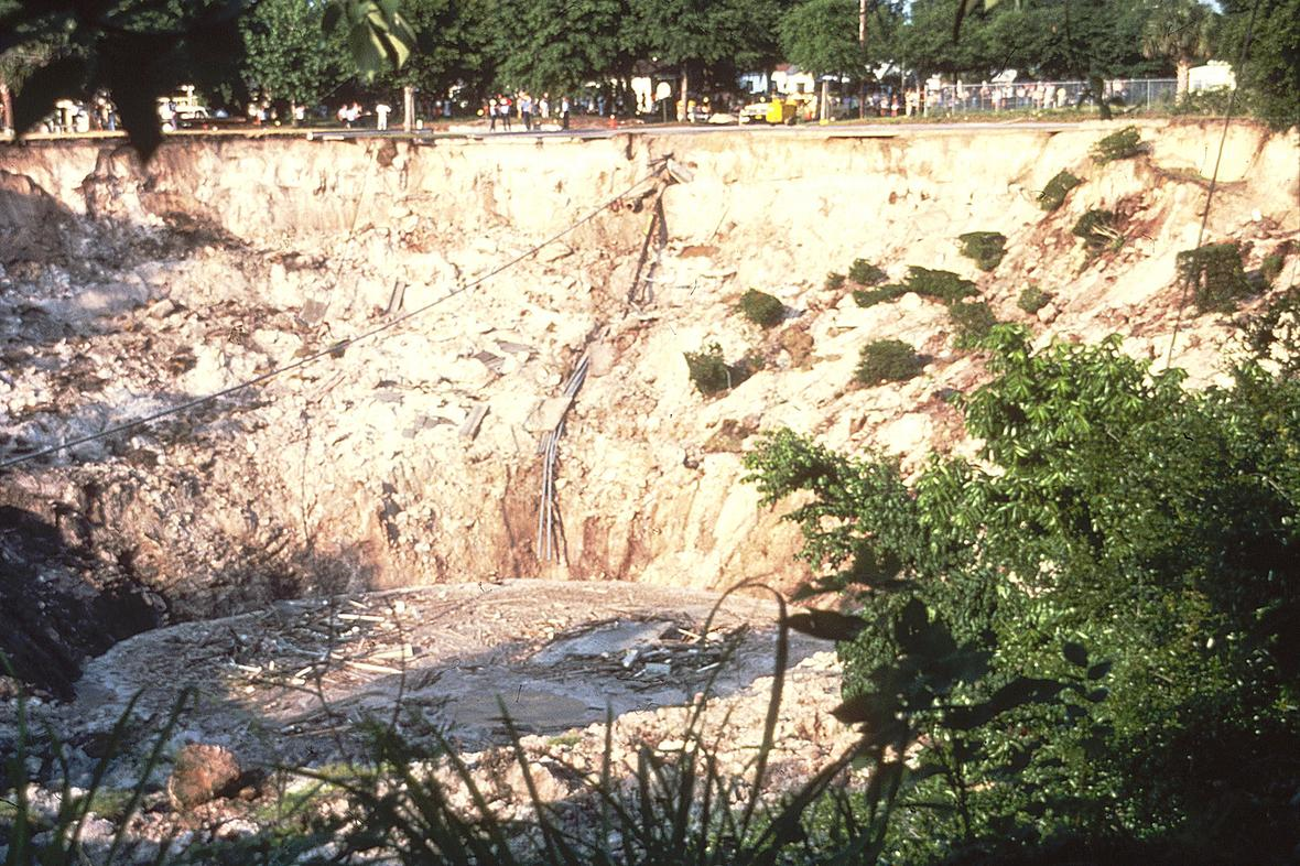
- Winter Park Sinkhole (1981): One of the most famous Florida sinkholes, this cover-collapse event opened in May 1981 in Winter Park, Orange County. The sinkhole eventually grew to 350 feet wide and 75 feet deep, swallowing a house, several cars, a swimming pool, and portions of two streets. It is now a lake.
- Seffner Sinkhole (2013): In February 2013, a sinkhole opened beneath a house in Seffner, Hillsborough County, fatally engulfing a man sleeping in his bedroom. The event drew national attention to the danger of Florida sinkholes and the difficulty of predicting their occurrence.
- Land O' Lakes Sinkhole (2017): A massive sinkhole in Pasco County measured approximately 260 feet wide and consumed two homes. The event underscored the ongoing sinkhole hazard in west-central Florida's "Sinkhole Alley."
Warning Signs of Sinkhole Activity
While cover-collapse sinkholes can appear suddenly, many Florida sinkholes give warning signs before full collapse. Being alert to these indicators can help protect life and property:
- Cracks in walls, floors, or foundations: New or expanding cracks, particularly those radiating from a central point, may indicate ground subsidence.
- Doors and windows that stick or won't close properly: Ground settlement can shift door and window frames out of alignment.
- Depressions in the yard: Circular or oval-shaped depressions that appear or deepen over time, particularly those that collect rainwater.
- Fence posts, trees, or utility poles that tilt: Leaning structures may indicate that the ground beneath them is subsiding.
- Sudden turbidity in well water: Cloudy or muddy well water can indicate that sediment is being disturbed by underground ground movement.
- Small holes appearing in the ground: Particularly holes where soil seems to be "draining" downward.
- Ponding of water in unusual locations: Changes in surface drainage patterns may reflect subsurface subsidence.
What to Do If You Suspect a Sinkhole
- Evacuate if the situation appears dangerous. If you observe active ground movement, sudden depression formation, or structural damage to a building, leave the area immediately.
- Contact your local building department or county emergency management office. They can assess the situation and determine whether immediate action is needed.
- Hire a licensed geotechnical engineer or geological consultant. Professional assessment, including ground-penetrating radar (GPR) and standard penetration testing (SPT), can evaluate subsurface conditions and determine the extent of any void development.
- Contact your insurance company. Florida is one of the few states with specific sinkhole insurance provisions. Document all damage with photographs.
- Do not attempt to fill the sinkhole yourself. Improper filling can mask ongoing geological activity and create future hazards.
The Floridan Aquifer Connection
Florida sinkholes are intimately connected to the Floridan Aquifer — the vast underground water system that occupies porous zones within the state's limestone bedrock. The aquifer is both a cause and a victim of sinkhole processes:
- The groundwater flowing through the Floridan Aquifer is the primary agent of limestone dissolution that creates the underground voids leading to sinkholes.
- Changes in the aquifer's water level — whether from drought, excessive pumping, or seasonal fluctuation — can trigger sinkhole collapse. When the water table drops, the buoyant support it provides to overlying sediments is reduced, potentially triggering the failure of weakened cavity roofs.
- Sinkhole formation in turn affects the aquifer by creating new recharge points where surface water enters the groundwater system directly — potentially introducing contaminants.
The relationship between groundwater pumping and Florida sinkholes is well documented. During droughts, when water demand is highest and the water table is lowest, sinkhole reports increase significantly. This connection underscores the importance of sustainable water management in a state built on soluble limestone.
Sinkholes and Development
As Florida's population continues to grow, development increasingly extends into sinkhole-prone terrain. Geological surveys before construction are essential in high-risk areas. The Florida Geological Survey provides subsurface geological data and maps to assist in land-use planning.
Standard geotechnical investigations for construction in sinkhole-prone areas typically include:
- Ground-penetrating radar (GPR): Non-invasive imaging of subsurface conditions to detect voids and soil irregularities.
- Standard penetration testing (SPT): Borehole testing that measures soil and rock consistency at various depths.
- Cone penetration testing (CPT): A complementary borehole method that provides continuous profiling of subsurface conditions.
- Geological mapping: Review of existing geological data and maps to assess the site's position within the broader karst landscape.
Climate Change and Florida Sinkhole Risk
Several factors associated with climate change may influence future Florida sinkhole frequency:
- Increased drought intensity: More severe droughts lead to greater water table declines, which can trigger cover-collapse sinkholes.
- Heavier rainfall events: Intense rain can rapidly saturate overburden materials, adding weight that may trigger collapse of weakened cavity roofs.
- Increased groundwater demand: Population growth and agricultural demand, combined with changing precipitation patterns, may lead to increased aquifer pumping — a known trigger for Florida sinkholes.
- Sea level rise: In coastal areas, rising sea levels may alter groundwater chemistry and flow patterns, potentially affecting dissolution rates.
While the fundamental geological conditions that produce Florida sinkholes are unchangeable — the limestone is not going away — the human factors that influence sinkhole triggering are within our control. Sustainable water management, responsible development practices, and informed land-use planning are the most effective tools for living safely in Florida's karst landscape.
Frequently Asked Questions About Florida Sinkholes
Does homeowner's insurance cover sinkhole damage in Florida?
Florida law requires property insurers to provide coverage for catastrophic ground cover collapse, which covers sudden sinkhole events that cause structural damage. Broader sinkhole coverage — which includes more gradual subsidence damage — is available as an optional add-on in most policies. However, obtaining sinkhole coverage can be difficult and expensive in high-risk areas. A geological assessment is often required before coverage is issued.
Can sinkholes be predicted?
Individual Florida sinkholes cannot be predicted with certainty in terms of timing or exact location. However, sinkhole-prone areas can be identified through geological mapping, historical data analysis, and subsurface investigation. Ground-penetrating radar and other geophysical methods can detect subsurface voids and soil irregularities that may indicate developing sinkholes, but these methods cannot determine when or whether a collapse will occur.
How deep do Florida sinkholes go?
Florida sinkholes vary enormously in depth, from shallow depressions of just a few feet to dramatic collapses exceeding 100 feet deep. The depth depends on the thickness of the overburden, the size of the underlying limestone cavity, and the type of sinkhole. Most residential sinkholes are relatively shallow (10–30 feet), but large cover-collapse events can be much deeper. The Winter Park sinkhole of 1981 reached a depth of 75 feet.
Are Florida sinkholes becoming more common?
The number of reported sinkholes in Florida has increased in recent decades, but this likely reflects a combination of factors: increased development in sinkhole-prone areas (more structures to damage means more reports), greater public awareness, and better reporting mechanisms. Whether the actual geological rate of sinkhole formation is increasing is harder to determine. Increased groundwater pumping and changing precipitation patterns may contribute to a genuine increase in triggering events.
Is the Treasure Coast safe from sinkholes?
The Treasure Coast has lower sinkhole risk than central and west-central Florida. The intact Hawthorne Group confining layer, the Anastasia Formation substrate along the coast, and the thick sedimentary section above deep limestone all reduce risk. However, sinkholes are possible anywhere in Florida where limestone exists beneath the surface. Inland areas of the Treasure Coast may have different risk profiles than the coastal strip. Professional geological assessment is recommended for any significant construction project.